
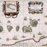
“Moluccæ Insulæ Celeberrimæ”. Blaeu’s map, which first appeared in 1630 in the Atlantis Appendix., was the first large-scale, detailed map of the now Dutch-controlled islands. It shows the heavily forested nature of the islands and the recently constructed forts. North is on the right direction, with Ternate in the rightmost island followed by Tidore, Mare, Moti and Makian islands. The bottom is the Gilolo (Jailolo or Halmahera) Island.